Since the advent of the first Covid-19 lockdown in California in mid-March 2020, Nancy and I have taken weekly day-trips to explore our region. Fully cognizant of the need to socially distance ourselves from others during the pandemic, we’ve walked, hiked, climbed and driven through remote areas within 100 miles of Bakersfield, California. In most cases we never met another person.
We’ve sometimes ventured further afield and driven as far as 175 miles from home, but we always returned by evening.
We made this a bit more challenging and even more fun by doing all of this in an EV. Of the nearly fifty trips we’ve taken, we’ve had to occasionally charge along the way for a few trips that exceeded the roundtrip range of our Chevy Bolt. The network of DC fast-charging stations has expanded greatly since we first started driving electric seven years ago, making a charge stop along the way much easier than it once was.
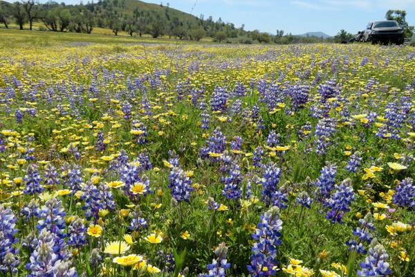
Wildflowers along Shell Creek Road.
Below is a list of places we’ve visited, trails we’ve taken, and in some cases the routes we’ve driven. Our longest trip was to botanize in Horseshoe Meadows above Lone Pine. That’s a three-hour drive plus a charge stop on the way up and the same on the way back. We left before sunrise and returned by sun down, allowing us about four hours rambling the meadows.
See our presentation Pandemic Peregrinations or How We Escaped Lockdown to the Sierra Club’s Kern-Kaweah Chapter by Zoom on the 6 March 2021 for pictures of some of the places we visited.
The longest hike we took was the Tule Elk Trail at Wind Wolves Preserve where we logged nine miles and a 1,000 foot of elevation gain.
We visited some destinations more than once. This includes Mount Pinos where we hiked to the summit four different times to see the changing displays of wildflowers. We also hiked four trails in Red Rock Canyon State Park at different times.
If you plan to use Forest Service roads, venture off the paved state highway system, or hike, we strongly recommend taking good maps, either paper topo sheets or digital maps loaded onto your smart phone. The latter are “geo-referenced.” This allows you to pinpoint your location without a compass. For hiking in a group, radios are valuable for keeping everyone together. We keep a “to go” bag ready with all our gear for the next adventure.
While the pandemic has been tragic for hundreds of thousands of Americans, and disastrous for the country, we’ve tried to keep our sanity by getting out and exploring the wonderful part of the world where we live. We encourage others to get out and explore.
- Sand Ridge Wildflower Preserve National Natural Landmark: Only 20 minutes from Bakersfield with a fine view of Caliente Creek and Bear Mountain. https://goo.gl/maps/fZcXJhVdFBBWMTkW6
- Kern Canyon Trail: Again within a half hour of Bakersfield. Walk as far as you want in either direction. https://goo.gl/maps/WDybA76TiV6PbqqL8
- Mill Creek Trail: Another trail head close to Bakersfield. https://goo.gl/maps/rnJybeHyo2jWR3sy8
- Carrizo Plain National Monument: An hour west of Bakersfield with lots of room to explore. https://goo.gl/maps/nGbecypJKJzY7g3k9
- Hart Park: Right in our backyard. Go to the end of the road and explore.
- Shell Creek Road: An hour and half west of Bakersfield with spectacular wildflower displays in a good year. https://goo.gl/maps/cQFsZoSwv4SqTws19
- Antelope Valley Poppy Preserve-Pine Canyon Rd: We made this a loop trip with fine views over the Antelope Valley from Pine Canyon Road. https://goo.gl/maps/t1NGnNLTdoiUKk2K8
- Kelso Valley & PCT: Take a jaunt on the PCT from the drainage divide between Kelso Valley and Jawbone Canyon. https://goo.gl/maps/S7SysNRCLQwzwty38
- Cameron Ridge PCT Tehachapi Segment: This is a six-mile hike from Cameron Canyon trail head at the other end of Cameron Canyon and follows Cameron Ridge. This is the route of the Sierra Club’s annual windmill-wildflower hike. https://goo.gl/maps/mYkVUxnw6Rfn4rGi6
- Sherman Peak Trail: https://goo.gl/maps/Yt7LEKEyp9jKBaey5
- Lehigh Trail Tehachapi: The area near the Monolith cement plant is laced with mountain bike trails. Hikers are permitted. Just keep an eye out for the cyclists. A map is available on line. https://goo.gl/maps/PrkFgG29JdUyouP38
- Chimney Creek Road: This is a graded Forest Service road from Hwy 178 to Nine Mile Canyon Road. https://goo.gl/maps/CgmKCmyJKKcdjmU47

- Dome Rock: Spectacular setting with a view of “The Needles” from the Great Western Divide highway. Easily accessible on foot. https://goo.gl/maps/hAvPbAyP7Lu7GfCm8
- Horseshoe Meadows: Alpine destination after one of California’s most scenic drives deep into the Sierras from Lone Pine. The Meadows are a great jumping off place for numerous hikes into the backcountry. https://goo.gl/maps/egthPMAe62K9bKU88
- Bald Mountain Botanical Area: A moderate hike from the parking area or you can drive almost to the summit. Great views in all directions and the reason there’s a fire lookout tower on the summit. https://goo.gl/maps/ba4tpffswbUrojhw6
- Mount Pinos-Sawmill Mountain Trail: Moderate seven mile hike from the parking lot to Mount Pinos and then on to Sawmill Mountain and return. https://goo.gl/maps/k1Xg5bqKZJbq5C9v7
- Sunday Peak Meadows: Just beyond Portuguese pass the wet meadows are a good place to botanize. https://goo.gl/maps/ksbQtS7EuKmtNTbo8
- Breckenridge Mountain: This is car trip to the campground and the nearby meadows. Those with a high-clearance vehicle and an adventurous spirit can take an ungraded Forest Service road to the summit. We did it in a Bolt. https://goo.gl/maps/GZdkTjHCnP3mjXEVA
- Oak Flat Lookout: Forest Service graded road and a short walk to the fire lookout tower. https://goo.gl/maps/zoEqiz8ACXsf34nX6
- Red Rock Canyon: The first link is to the rim trail that begins in the campground. The second is to the Hagen Canyon trail. The third points to a picnic bench in an area locally called Red Rooster Canyon. https://goo.gl/maps/mG2NL17N7xoYtVw26, https://goo.gl/maps/dwByHxWBmwkfDwVG7, https://goo.gl/maps/CTqkjLi9gdjY6Ehg8
- Tehachapi Mountain: Five mile round trip hike with 2,000 feet of elevation gain. Not a blazed trail and the final section is on private property. https://goo.gl/maps/74y7cSQ6jB1dXhMm9
- Miracle Mine, Erskine Road, Bull Run Creek: The first is the former uranium mine above Hobo Hot Springs on the Kern River. The second link follows the fault along Erskine Road. The third link is to the Whiskey Flats trail that crosses Bull Run Creek. https://goo.gl/maps/eGoecWPUa4iMthnn8, https://goo.gl/maps/b9rN2LUz6fdDPgPDA, https://goo.gl/maps/CPXRgcLxaridmxgV9
- Chimeneas Ecological Reserve, and Aliso Canyon Trailhead: The first link is to the access of to Chimeneas Ranch from Hwy 166 west of Cuyama. The second link is to the campground at the end of Aliso Canyon road. https://goo.gl/maps/XC78u3XQy4H98hgu9, https://goo.gl/maps/721wJnvEdjzBBsKB7
- Reyes Creek Trailhead, Ballinger Canyon, and Santa Barbara Canyon: This is a road trip exploring Lockwood Valley and the Cuyama Valley. https://goo.gl/maps/kmkvK4AsnhRsS4GE6, https://goo.gl/maps/M9uQc47HZhDhfmZ88, https://goo.gl/maps/rXzq457cWi8KMxdz6
- Bull Run Creek Stamp Mill Ruins: There is no marked trail to the ruins of the stamp mill. There are several use trails from the Whiskey Flats trailhead that lead up Bull Run Creek to the mill site. https://goo.gl/maps/b1dwPiBPpoXo8soTA
- Goler Wash, Mesquite Springs, and Red Rock Canyon State Park: There is a sag pond on the El Paso fault at Goler Wash and the Randsburg-Garlock road. Mesquite Spring is just that on the El Paso fault. The last link is to the Red Cliffs nature trail in Red Rock Canyon State Park. https://goo.gl/maps/RgL4GB1j13iJZABe9, https://goo.gl/maps/43P6uBcCkZrMrsRR8, https://goo.gl/maps/92TZyZtaNrDkY73L8
- Wind Wolves’ Tule Elk Trail: This is an 8-9 mile hike with 1,000 feet of elevation gain in the San Emigdio Mountains. https://goo.gl/maps/yzHUz32CC27xgTtr8
- Saddleback Butte State Park: It’s a 5.5 mile hike through sand with 1,000 feet of elevation gain to the summit of Saddleback Butte and back. Well worth the view. https://goo.gl/maps/U1wyJnyB5vHfEHme8
- Bitterwater Road, Simmler, Carizzo Plain, and Soda Lake overlook: This is a car trip exploring the San Andreas Fault zone. https://goo.gl/maps/DCJW5kfnZJoYQi3w5
- Tule Elk Preserve & Elk Hills Road: A quick trip for a picnic from Bakersfield or for a look at one of the world’s most productive oil fields. https://goo.gl/maps/LG1Wj1iA5QesQAtJA

- Nightmare Gulch, Red Rock Canyon State Park: No need to drive to Death Valley. You can experience the same terrain with a six mile round trip hike through Nightmare Gulch. https://goo.gl/maps/23vvCZ8Rp9eoibX3A
- Munz Road Aqueduct Road in the Antelope Valley: Walk as long as you want on the flat access road alongside the California Aqueduct from the gate on Munz Road. https://goo.gl/maps/HUuLjBWzgjXM7mE56
- Arthur B Ripley Desert Woodland State Park: Two short trails take you through one of the last Joshua Tree Forests in the Antelope Valley. https://goo.gl/maps/8waNjRrXz9Wr9Fbm7
- Kaweah Oaks Preserve: Short walks in a preserve of riparian habitat near Visalia. https://goo.gl/maps/UtVevxsWAMmoANHy5
- Coalinga Mineral Springs Trail: 5.2 mile round trip hike to the summit of Kreyenhagen Peak. The area burned in 2020. It’s a bleak post-fire landscape. https://goo.gl/maps/ktFkqwbcfXfmy6jp9
- Castaic Lake to Lake Hughes Road and Pine Canyon: This is car trip and a good portion of Lake Hughes Road was burned in 2020. https://goo.gl/maps/fVbiMQykfqr4nVWm6
- Castaic Lake North on the Old Ridge Route: High clearance vehicles only, though we did it in a Bolt. Don’t try this route when it’s wet. https://goo.gl/maps/ubcfuAYB7U2Q2JZK7
- Piru Gorge to Pyramid Dam: 4.5 mile out and back trail on old Hwy 99 from the Frenchman Flat’s campground to the base of Pyramid Lake dam. Prominent outcrops of Ridge Basin sedimentary rocks including ripple marks. https://goo.gl/maps/RoCxESiuQp9p2z2w8
- St Francis Dam Disaster Site on San Francisquito Canyon Rd: This is another car trip. This route goes from I-5 at Santa Clarity east bound to Elizabeth Lake. It passes through a canyon famous for the power plants, penstocks, and power lines of LADWP. It’s also infamous for the St Francis Dam Disaster. There’s an old road that where you can walk to the dam site. Roundtrip is about 2 miles out and back. The first link is to the dam site. The second is the route we took.https://goo.gl/maps/EPtnYVKsJDqdvHPg8, https://goo.gl/maps/spX8DBxsAT7szK3Q8
- Wallace Creek Interpretive Trail along the San Andreas Fault on Carrizo Plains National Monument. https://goo.gl/maps/p9ZvTRv8qQvbfkPg9
- Pacific Crest Trail Northbound, Walker Pass Trailhead. Dry and hot but spectacular vistas beginning at 5,200 feet. https://goo.gl/maps/BjNWeQmHcsdn2kgA8
- Kern Canyon Trail Southbound parallel’s the river and Hwy 178. https://goo.gl/maps/zJx1PA5TNd6B36cVA
- St. Francis Dam Disaster site on San Francisquito Canyon Road midway between Valencia and Green Valley. The drive through the canyon alone is worth the trip. https://goo.gl/maps/3HnzrhhefRS38an3A
- Weedpatch Camp made famous by John Steinbeck in the Grapes of Wrath just south of Lamont. https://goo.gl/maps/geYu35qVPkxB8uKL6
- National Cemetery off Hwy 58 and Bear Mountain Blvd. https://goo.gl/maps/QrJNoiGAH4uDbXFe6
- PCT Northbound from Bouquet Canyon (Seasonal Water Point). Best early in the season, February or March to mid-April. By May this segment will be very warm midday. Chaparral with little shade. https://goo.gl/maps/uUZCo8k9UZwWnGtm6
- Great Western Divide Hwy via Springville, Quaking Aspen, Dome Rock, Trail of 100 Giants, Forest Route 23S16 to Greenhorn Summit and Hwy 155 back to Bakersfield. From M50 to Portuguese Pass note that the road is paved but very narrow. Drive with extreme caution. We met only one other vehicle but they were driving much too fast for the conditions and it was a near miss! Spectacular views and very remote. https://goo.gl/maps/h7kTqTDfJccXk3eLA
- Shirley Meadows (Cooks Peak south side) in search of the rare Greenhorn Fritallary and Shirley meadows star tulip. Graded dirt road passable in our Bolt. Rancheria road is closed so we returned the same way we entered. https://goo.gl/maps/NPro6YCeJMLkp7sH8.
- Baker Point Lookout is a two-hour drive from Bakersfield and a 2.75 mile roundtrip hike with 500 feet of elevation gain but worth every bit of it. The abandoned lookout is in the midst of a botanical preserve and we saw the endemic Kern swertia or Kern Frasera (Frasera tubulosa) on our hike. We also found another endemic Colville’s wyethia (Wyethia invenusta) on the rocky trail to the lookout. Here’s the location: https://goo.gl/maps/FDeMdSQKm3DzvVmb8. Here’s the route we took from Bakersfield: https://goo.gl/maps/iYdawqpkLwiLuTgq5.
- Darwin Falls on the western edge of Death Valley National Park is a 3.5 hour drive from Bakersfield via Ridgecrest, California and the Panamint Valley. This requires one charge stop at Inyokern in a Chevy Bolt or equivalent EV. You can make a big loop by returning via a charge stop at Coso Junction. The falls are a two mile roundtrip hike. This is a trip in an EV that’s best done with an overnight in Ridgecrest. https://goo.gl/maps/L4paE2mz3zGTeSx9A See Covid Escape: Darwin Falls via Ridgecrest and Return via Coso Junction for more information.