Since our botanical excursion to Horseshoe Meadows on the Sierra’s East Side we’ve taken four more Covid-19 Escapes from Bakersfield in our Bolt EV. These are solely day trips and within the Bolt’s range on one charge.
We’ve driven the Bolt more off paved roads than we’ve ever done before as we push farther and farther into the Sequoia National Forest northeast of Bakersfield to areas we’ve never been before.
Unfortunately, fires and smoke scuppered our most recent plans. So instead we headed east to Breckenridge Mountain where Forest Service web cams indicated the smoke wasn’t quite so thick.
Only 1.5 hours from Bakersfield, Breckenridge Mountain is surprisingly unfrequented mid week. We met only one other vehicle the entire time climbing the mountain.
The route takes you from the seemingly barren grasslands of the Valley foothills, through oak woodlands, and finally into Jeffrey Pines, spruce, and red firs on the summit. At times it felt as though we were in a very brown version of Scotland’s Highlands.
Once atop the mountain we stopped at Squirrel Meadow and imagined what it would like with spring wildflowers. The cool air, the scent of pine, and the quiet were a welcome respite from hunkering down at home during the pandemic. It was a welcome escape from the heat and the smoke.
We then checked out the dusty Forest Service campground. There were maybe three campers there and that was all. It may be worth a return visit to spend the night.
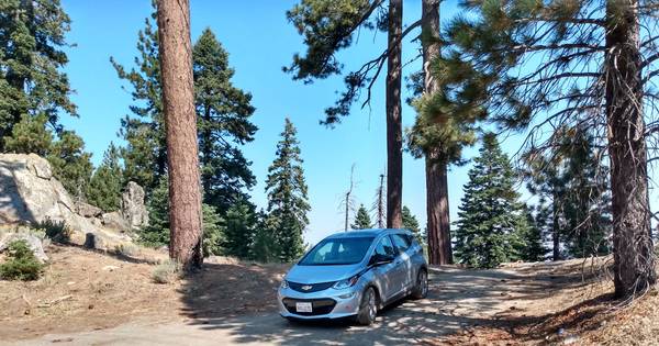
Then we decided to tackle the summit. I hadn’t given the idea much thought. It was just as well or I would have fretted over the terrain and whether the Bolt could do it–and get back as well. But I had GPS-enabled Forest Service maps with us that would at least show us the correct route.
From Breckenridge Road (Forest Service road 28S06) we took the unimproved Forest Service road 28S07 five miles to the summit and the fire lookout tower at 7,500 feet (2,300 meters). It was slow going, but we were not in a hurry. I would not have wanted to try this is a Model 3. Tesla’s Model X with its high clearance would be able to do it but the low-slung Model 3 might get hung up. As it was we had to carefully negotiate some sections.

We encountered only two other vehicles on the dirt track to the summit, both fourwheel-drives: an open top Jeep modified for off-roading and a big Ford F-150. Both drivers looked quite surprised to see us headed uphill as we squeezed past them on the narrow road.
Surprisingly, the lookout hasn’t been automated even though there are webcams mounted on the tower. There was someone in the tower when we were there and a crew working on a communication tower on a nearby ridge. They’d obviously got up there with a big utility truck and trailer so the road is passable for service trucks. Still, it’s likely we’re the first to drive an EV to the lookout tower.

We found California fushia (Epilobium canum) and rabbitt brush (Ericameria nauseosa) in bloom on the summit. Down below near the campground we found Penstemon newberryi and Sierra gooseberry (Ribes roezlii) in fruit.
We took the long sinuous route down the east side of the mountain gradually crossing the chaparral on the lower slopes until we hit the Caliente-Bodfish road. We headed back to Bakersfield via the broad expanse of Walker Basin while passing the recently scorched earth of the Stagecoach fire, dropping down in to the railroad siding of Caliente and basically following the tracks on into the sprawling city.
It was a day well spent. The Bolt got us there–and back.